
The Shetlander who mapped Jamaica
Shetland’s assistant archivist Joanne Wishart was in Edinburgh on Thursday night to give a sell-out talk on a little-known islander who produced a remarkably accurate map of Jamaica in the late 18th century.
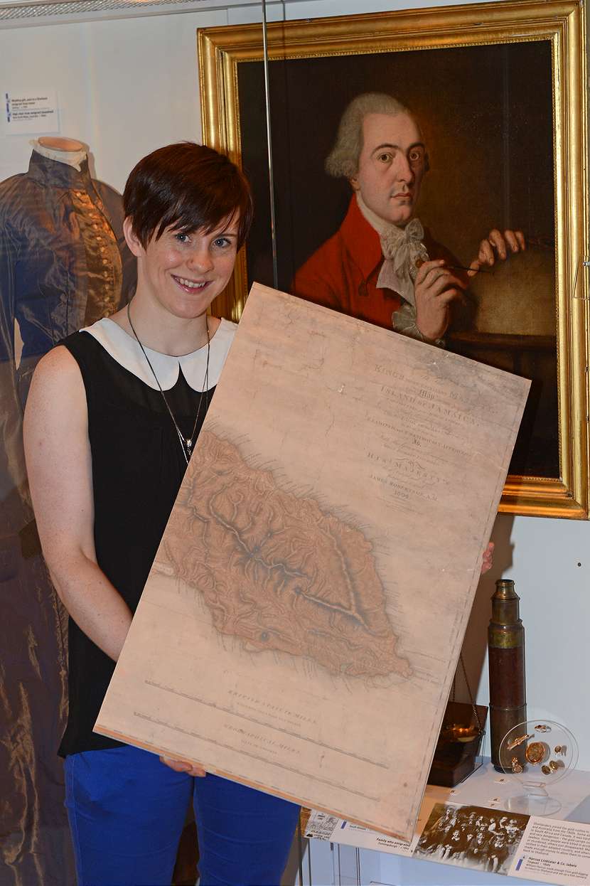
Surveyor and mapmaker James Robertson, born in 1753 and raised in Gossabrough, Yell went to the Caribbean to seek his fortune after completing university in Aberdeen.
The talk, entitled “James Robertson: The Shetlander who mapped Jamaica”, tells of how he became the first person to produce a full map of the island.
Joanne’s interest in Robertson was first piqued after a member of the public visited Shetland Museum in 2010 to ask how “this boy from Gossabrough”, a small hamlet on Yell’s South-East coast, had become a fellow of the Royal Society.
“In attempting to answer that question, I got a bit hooked on old James Robertson and his stories,” Joanne said. “He had a high opinion of himself and his work.”
Robertson came from a merchant class background – his father imported goods from Germany for wealthy 18th century Shetland families. After emigrating he produced an “incredibly detailed and impressive map” of Jamaica during the sugar boom.
After being discovered and claimed for Spain by Christopher Colombus, Jamaica fell under British rule in 1655 and remained that way for over 300 years. It gained full independence in 1962 and is now a member of the Commonwealth.
Joanne said her talk at the National Library would explore every aspect of the “egomaniac” Robertson – incorporating his life and career in the Caribbean, and why he was unable to replicate his success there upon returning to the UK later in life.
The height of the sugar rush saw thousands of Scots sailing west to work as plantation managers, bookkeepers, clerks, politicians and in various other occupations in Jamaica. Robertson was part of that wider emigration: “There was money to be made,” Joanne said. “That was, I think, his main aim for going.”
Although it has been difficult to verify Jamaican archive information from the other side of the Atlantic, Joanne has been able to glean that in 1796, Robertson put a proposal to the Jamaican House of Assembly. He pointed out that no-one had made a full map of the island and requested that politicians commission him to produce one.
“They agreed this was the thing to do, and he spent the next five years producing one map of the whole island and three very detailed maps of each of the three counties in Jamaica.”
Robertson was awarded over £10,000 – more than £300,000 in today’s money (“not to be sniffed at”) – and had completed the project by 1802.
Researchers have plotted Robertson’s Jamaica map over a modern-era photograph and it “matches up not too bad”, Joanne said. A Jamaican academic who visited Shetland recently thinks it’s accurate “to within two per cent”, which was pretty good “given the tools he had” at his disposal.
Robertson’s portrait is on show in the upstairs display of the Hay’s Dock museum. “He’s an interesting man – it’s good we’ve got that, it brings it to life a lot more,” Joanne said.
After returning to the UK to get his maps engraved and published, Robertson lived the high life in London’s Pall Mall and was elected a fellow of the Royal Society.
The latter days of his career were rather less successful. Robertson came back home to survey Shetland, but was unable to find a patron to fund its publication. “He produced no map of Shetland, as far as I can tell,” Joanne said, “which is a shame.”
Robertson’s career would end in somewhat ignominious fashion. He was commissioned to produce a new map of Aberdeenshire, but it turned out to be “a bit of a disaster”. It took over a decade to complete, and even then the map committee wasn’t satisfied.
Joanne said the committee felt it contained mistakes, including the omission of some major roads, and Robertson was left “humiliated” when another engineer was brought in to check over the map.
It was eventually published in 1822, 12 years after he began work on it, but a dispute over the rights and wrongs continued even after Robertson’s death in 1829.
“It was not such a glamorous tale as the Jamaica one. There were accusations that he’d traced bits of it from another map – it was all a bit controversial.”


NO COMMENTS
Add Your Comment